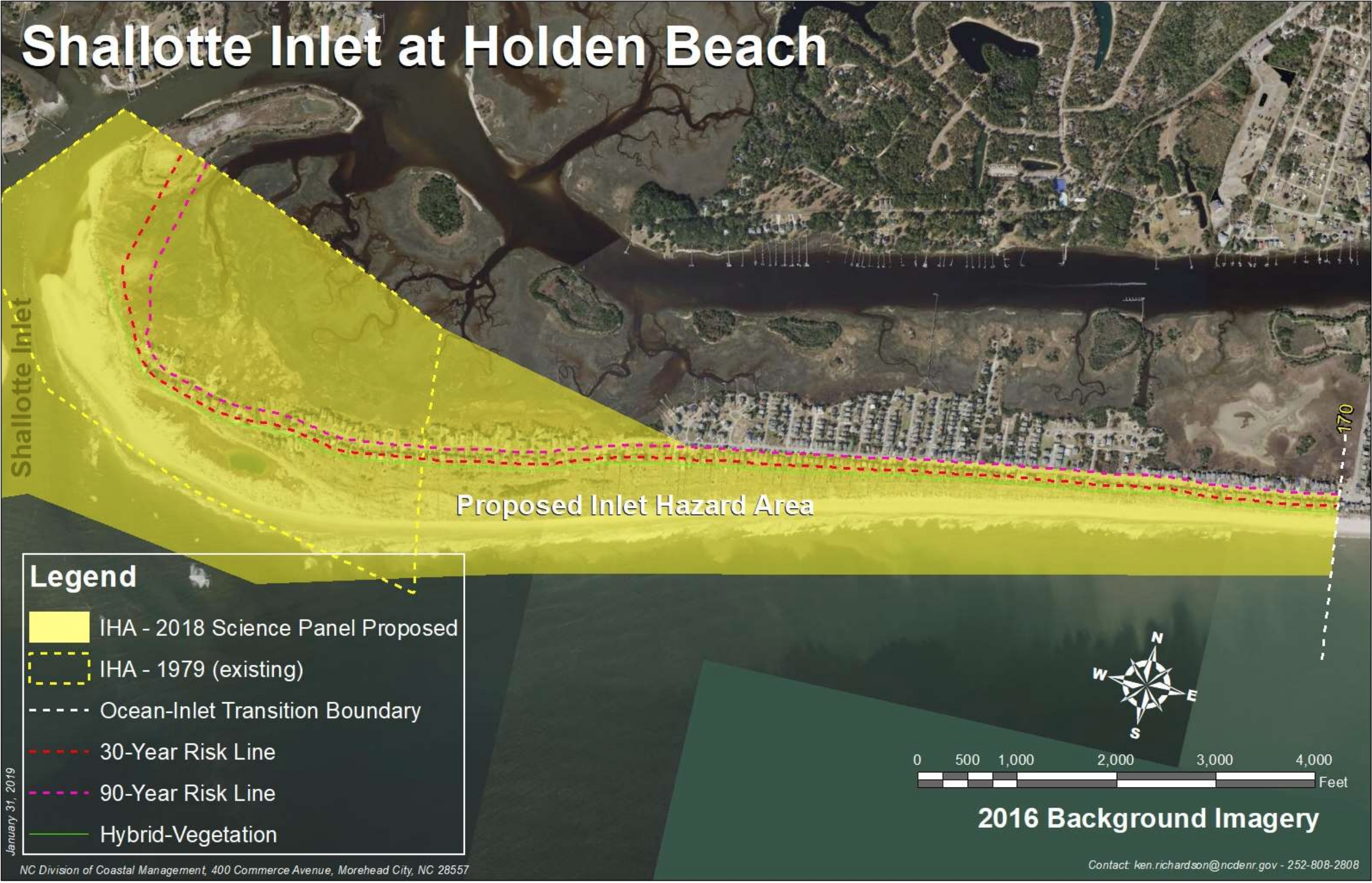
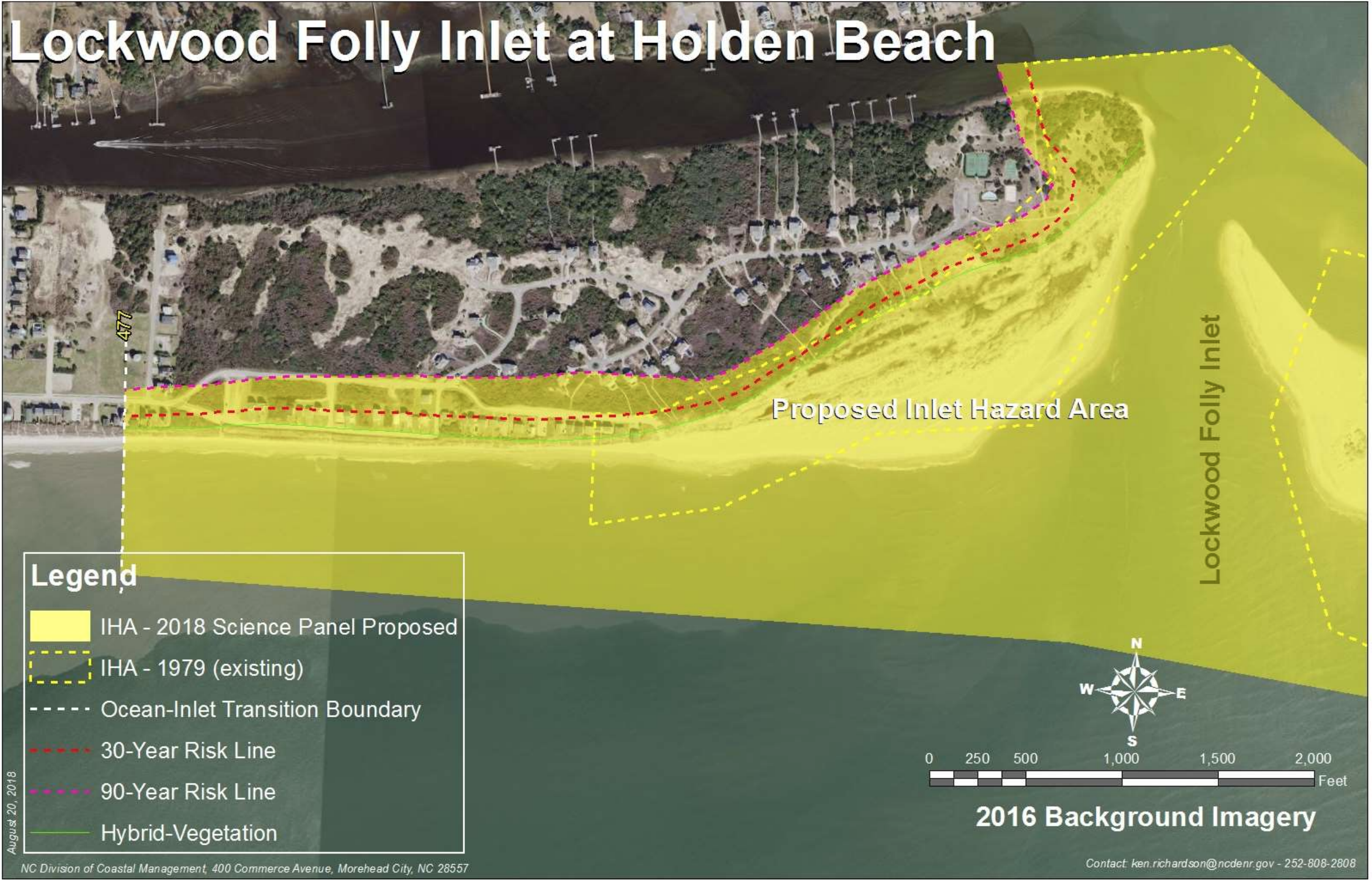
See the Update as of March 17, 2023, Below.
Is your property in one of the areas marked in yellow above? If so, you need to be aware that there are proposed changes to the Inlet Hazard Areas (IHAs) that could significantly impact what you can build or rebuild on your property. These changes could reduce the value of properties in the IHA, which would impact all property owners on the island by impacting our overall tax base.
IHAs are defined as shorelines especially vulnerable to erosion and flooding where inlets can shift suddenly and dramatically.
You can zoom in on your property by clicking here. After going to the site, to see the proposed new IHAs go to the Layers icon and click on “Inlet Hazard Area (2019) – pending adoption”. To very clearly see your property click the icon of four stacked boxes on the map and select the imagery view. You can also click here for IHA Map Instructions.
Impacts
The proposed rule changes include the boundaries of the IHAs and the rules for development in IHAs. For Holden Beach, the areas in the IHAs are greatly expanded. The West End IHA will grow by 96% and run from the Shallotte Inlet to almost Sailfish Street. The East End IHA will expand by 195.6% and run from the Lockwood Folly Inlet to past Blockade Runner.
The HBPOA Board has passed a resolution in opposition to the proposed changes.
Town staff is still reviewing the implications of the proposed changes but it appears that for properties in the IHAs the development rules will include:
- No new structures greater than 5000sf (commercial and residential are treated the same)
- Existing homes built prior to August 2009 are grandfathered in the same footprint if they cannot meet the new setback requirements should they be destroyed or damaged more than 50% by storms, fire, etc.
- All lots must be a minimum of 15,000sf
- Setbacks will be calculated based on the inlet erosion rate, not the adjacent oceanfront erosion rate, as it is currently done
- A Hybrid Vegetation Line will be used to measure setbacks, similar to a Static Vegetation Line, unless the actual vegetation line is more landward.
- Per area realtors and the Building Inspector – can limit pool building, can require no slab under homes, will require a signed notice of risk from future buyers, will “stigmatize” these properties
- The impact on insurance is unclear. While Flood Insurance is a federal program, most insurers have a checkbox for IHAs on the application.
- There is no appeal process
Issues
- We have never lost a structure on the western part of the island – ever.
- The western part of the island has been accretional for recorded history. It has never been nourished.
- The geology and morphology of the island clearly show that the Shallotte inlet is not migrating east.
- Our Town’s beach engineer has detailed annual surveys of the island going back over 20 years which show the inlet is stable and the beach is accretional – but neither the Town nor our engineer were ever contacted for input.
- Some of the areas proposed to be included in the IHA are in “X” zones. LiDAR surveys used for FEMA flood maps offer detailed and highly accurate information, but were not included.
UPDATES:
As of March 17, 2023
At the September 15, 2022, Coastal Resources Commission (CRC) meeting the Commission unanimously adopted the updated IHA report and maps, inlet erosion rate setback factors, and amendments to use standards CRC Minutes September 2022. To address the issue of lots platted after 1979 that cannot meet the new IHA setbacks, Division of Coastal Management (DCM) staff recommended an amendment to these rules at the November 17, 2022, CRC Meeting held in Beaufort, NC. On February 23, 2023, the CRC met at Ocean Isle Beach. Property owners from Holden Beach, Ocean Isle, and Oak Island all spoke in opposition to the proposed changes. See their statements here:
Holden Beach POA CRC meeting comments 02-23-2023
Town of Ocean Isle Beach IHA Letter
Ocean Isle Beach Resident Johnson IHA Letter
At this time the IHA maps and corresponding rules have not been adopted. In discussions with the Division of Coastal Management (DCM) it has been suggested that the process of final adoption may not occur until later this summer (August 2023). It is important that property owners take advantage of submitting written comments or attending scheduled Public Hearings on this matter before it is too late. If you have questions or concerns, please do not hesitate to contact Ken Richardson, Shoreline Management Specialist with the NC Division of Coastal Management at ken.Richardson@nc.denr.gov or by phone at (252) 515-5433.
While the Town of Holden Beach did not speak at the meeting, they did send a letter to property owners who will be impacted along with a copy of the letter they sent in January 2020.
As of April 29, 2022
There is a final Public Hearing scheduled for May 3, 2022 at 11:00AM in the Brunswick County Government Complex – Council Chambers. Click here for other Public Comment sessions. You may also send written comments to the Division of Coastal Management, 400 Commerce Avenue, Morehead City, NC 28557 The Comment period closes June 17, 2022. After the Public Hearings the CRC will vote on whether to adopt the changes at their September 14-15 meeting.
This Public Hearing will be addressing these proposed changes:
2019_Inlet_Hazard_Area_Boundary_Update_20190212
15A NCAC 07H .0304 for public hearing
15A NCAC 07H .0306 for public hearing
15A NCAC 07H .0309 for public hearing
15A NCAC 07H .0310 for public hearing
OSBM Approved Fiscal Analysis 2019 IHA Update
As of March 8, 2022:
The CRC will be hosting an additional round of Public Hearings in Mid-Late April 2022 to take comment on proposed changes. This is required before they can adopt the new boundaries. The new IHAs could be adopted at their June 8-9, 2022 Meeting or the September 14-15, 2022 Meeting.
As of February 2021:
As of the February 2021 CRC Meeting, it appears this issue is moving forward. Despite massive public comment opposed to the changes, especially on the IHA for Holden Beach at the Shallotte River Inlet, the CRC and Science Panel remain unswayed.
CRC-21-02-Proposed-Inlet-Hazard-Area-Boundaries–Additional-Comments
CRC-21-03-Use-Standards-for-Inlet-Hazard-Areas
CRC-20-33-Inlet-Hazard-Area-Public-Comments
How to Comment
- Send an email to Braxton.Davis@ncdenr.gov and/or Ken.richardson@ncdenr.gov The comment period closes March 2, 2020.
- Attend the Public Hearing December 17, 2019, 10:00am, at the Government Complex in Bolivia.
- Attend the Workshop session with Mr. Ken Richardson, Shoreline Specialist with NC Department of Environmental Quality, at Town Hall on January 16 at 2:00pm. This session was requested by the Building Inspector because of the disproportionate impact this change will have on Holden Beach versus other coastal communities. There will be a short presentation then CRC staff will answer questions. They will not be recording comments but you can submit written comments to Ken which he will pass along to the CRC.
Background
In November 2018 the NC Coastal Resources Commission’s Science Panel presented a report on their efforts to update the state’s Inlet Hazard Areas (IHAs). This report includes background information on IHAs, a summary of the proposed changes, and maps. At their February meeting, a more detailed report was presented and voted on. Holden Beach West End begins on page 34 and the East End on page 38 of this report. The proposed changes were approved and sent to Raleigh for Fiscal Analysis. That report came back at their September meeting, and the CRC voted to move ahead with the changes. The next step is public input.
Process
The CRC’s Science Panel used aerial photos of the beach strand from 1970 through 2016 and mapped the vegetation lines over the years. They combined the landward most segments of these lines to get a Vegetation Line and by using a running average created a Hybrid Vegetation Line (HVL). Setbacks are measured from the HVL, not the actual current vegetation line as is currently done. They used linear regression to determine the erosion rate for each inlet. The 30-Year and 90-Year Risk Lines are calculated by multiplying the erosion rate and 30 or 90. If the erosion rate is less than 2′ per year or the beach is accretional, 2′ is used. From the Shallotte Inlet to east of the bridge the erosion rate set back factor is 2′, transitioning to 6′ closer to the Lockwood Folly Inlet. Click here to view the map.
More Information
December 19, 2020: Article on Public Hearing https://www.coastalreview.org/2019/12/states-inlet-hazard-plan-criticized-at-hearing/
January 8, 2020, Workshops Set: https://www.coastalreview.org/2020/01/inlet-hazard-update-workshops-set/
Visit the CRC webpage here: https://deq.nc.gov/about/divisions/coastal-management/coastal-resources-commission
Report from the Science Panel with recommended changes: Inlet Hazard Area Boundary, 2019 Update
Fiscal Analysis of the impact of changes: Fiscal Analysis CRC-19-24-Inlet-Hazard-Area-Update-Fiscal
Inlet Hazard Area (IHA) Update Report & Staff’s Proposed Amendments CRC Memo 19-07
Memo from Ken Richardson CRC 19-05 IHA Fiscal Analysis February-2019
Erosion Rates and Setback Factors 2019: 2019_Oceanfront_Setbacks_ErosionRate_Update_Report
Proposed Statute Changes:
15A NCAC 07H .0304 AECS WITHIN OCEAN HAZARD AREAS
15A NCAC 07H .0306 GENERAL USE STANDARDS FOR OCEAN HAZARD AREAS
15A NCAC 07H .0309 USE STANDARDS FOR OCEAN HAZARD AREAS: EXCEPTIONS
15A NCAC 07H .0310 USE STANDARDS FOR INLET HAZARD AREAS
Public Comment on Erosion Rates: https://www.coastalreview.org/2019/09/public-can-weigh-in-on-inlet-hazard-updates/
Rule Changes coming: portcitydaily.com-Development rules near inlets have been basically the same since 1981 This year that could change
IHA Changes: https://www.coastalreview.org/2019/03/crc-advances-new-inlet-hazard-maps-rules/
IHA Changes: Panel Proposes Redrawn Inlet Hazard Areas _ Coastal Review Online
February 2018 Presentation on IHAs Richardson Presentation


